St. Ives Maps and Orientation
(St. Ives, Cornwall, England, UK)
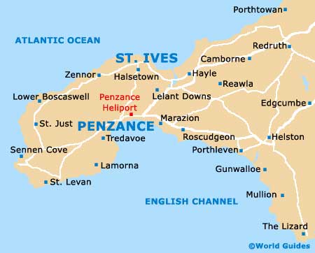
Located on the far western side of Cornwall, in the district of Penwith, St. Ives has become a popular place for summer holidays. Regularly attracting large numbers of visitors, St. Ives has much to offer and is easy to find by car, lying off the A30 and the A394. Once a busy village with a thriving fishing industry, life in St. Ives now revolves predominantly around its tourism, following the decline in fishing.
Maps and Orientation of the Town
St. Ives is close to the villages of Hayle, Gwithian, Lelant and Towednack, with notable local roads including St. Ives Road and also Castle Road, which heads south to Ludgvan. Many people arrive here to visit Porth Meor beach, renowned for its exceptional surf and lined by a number of self-catering holiday flats. Nearby, the suburbs of St. Ives are fairly hilly, with many steep areas.
Close to St. Ives, Penzance is sited directly south and is a popular day trip, offering a range of attractions. The main locations nearby St. Ives are listed below, together with relevant information about the distance and direction.
- Camborne - 20 km / 12 miles (24 minutes, east)
- Carbis Bay - 3 km / 2 miles (6 minutes, south-east)
- Falmouth - 43 km / 27 miles (one hour, east)
- Halsetown - 3 km / 2 miles (6 minutes, south-west)
- Hayle - 13 km / 8 miles (17 minutes, north-east)
- Hellesveor - 2 km / 1 mile (3 minutes, west)
- Helston - 34 km / 21 miles (34 minutes, south-east)
- Land's End - 31 km / 19 miles (45 minutes, south-west)
- Marazion - 11 km / 7 miles (18 minutes, south)
- Penzance - 13 km / 8 miles (22 minutes, south-west)
- Towednack - 5 km / 3 miles (10 minutes, south-west)
- Trink - 5 km / 3 miles (13 minutes, south)
Map of the United Kingdom

Map of Cornwall

Map of St. Ives